Trying to picture 18th century Carmunnock is not really very difficult today. The early cottages show some distinctive characteristics of the period. The rooms in the broad-based, sturdy-looking single-storey ones have low ceilings and since the thatch was removed, an upstairs exists under the new higher slated roof. Doorways are comparatively low and where windows have obviously been enlarged at some stage following Parliament’s abolishment of the window tax about 1798, they are nevertheless smaller than those in later-built houses.
But it is interesting that where window-spaces have been made bigger, the walls three or four boulders deep on some of the cottages, have been strengthened round these areas with the insertion of sandstone that has been patiently ground to rectangular or squared shape, the flat surface either scored or punched, dabbed and necked. Similarly, round the doors and at the rebuilt corners of old buildings, these dressed squares can sometimes be found.
It has to be said, however, that on all too few of Carmunnock’s buildings is it possible to see these insertions. The reason is of course, because the nobbly outer walls on a number of the older houses have been mortared smooth, cement-rendered or harled (roughcast) for protection against the weather, preventing us from identifying the stone.
There is another cover to try to explain: namely, why so many frontages are of this dressed sandstone. There could be various reasons for this: whereas the original rubblestone on the rear and gables of some old buildings is still to be seen, at some period in the cottage’s life it has been necessary to rebuild the fronts. The truth about some, however, is that their front walls have merely been faced in this way, leaving one or two layers of rubblestone boulders in the thickness behind.
The question is the period at which this rebuilding or simply facing was done - whether in the late 18th century as an improving operation or whether out of necessity when enlarging window spaces at some later time? If it was done early, the stone would have to be cut and ground, then by long hours of chiselling, scored, punched or necked to hold the mortar and to let the rain run off; if done in the later period, more efficient tools and methods would be used, but if in our modern centuries, the clean-cutting process by a stone-cutting machine may have been employed.
However, in houses built by private owners late in the 18th century (and in the 19th and early 20th), whereas the rear and gables of the building were quite often constructed mainly of rubblestone, the back windows and door in several of them were from the outset framed or faced with squared sandstone and the front walls built entirely of it.
There are other interesting details to mark this 18th century period or even earlier. Chimneys show support ledges or coping-stones that long ago also served to hold thatch ropes in place when these were secured round them. While two or three cottages in Carmunnock have crow-stepped gabling (corbie-stepping), on the others the coping or skew-stones at each side of the roof are plain, but end in a skew-putt which is a faintly grooved and gently upturned little stone ledge projecting at the foot of the slope. Except for the church’s more elaborate finish, skew putts in Carmunnock tend to be simple and unornamented, indicating that although the houses were well-built, they were for ordinary folk and artistic skills were not employed.
One or two of the old cottages have hinge-pins still securely in place on the thick stone walls outside the windows on which shutters hung before the days of affordable glass window panes. Conversions that have taken place in the 20th century to develop and modernise the old houses, faintly show areas where not only outside stairs have been removed but doors have been turned into windows or have been blocked up.
Some small patched-up areas may even indicate where long ago an unnecessary little window beneath the eaves of the low thatched roof was blocked up to save paying window tax. But there was another interesting reason for blocking up windows: namely, in buildings where horse hides were hung before tanning, and must be protected from the sun drying them out.
At least two of our old buildings in Carmunnock have cut corners - a groove cut from about shoulder high down to ground level, rounds off the sharp angle of wall-corners “tae let the barras go by” older villagers say. These indicate times long ago when the area immediately round a dwelling (nowadays probably a garden or footpath) was where the cottager worked at his trade.
Surrounded by its interesting graveyard, the church built in 1767 has a belfry of classic design which the Rev Charles Harrison reports in his Statistical Account of 1953-60 belonged to the former kirk building.
The outside stairways on the south, west and east walls lead to galleries inside the church which were originally for the families of the Castlemilk Lairds and those of Dripps and Cathkin. The Stuart family vault, approached through an iron door on the south of the building, is beneath their one-time Retiring Room (now the Session House) which adjoined the family’s gallery (where the organ is).
In the 18th century, the hamlet round the church - the kirkton (or kirktoun) of Carmunnock - consisted of a cluster of thacked or thatched cottages. Among these just south of the church gates were - and still are - the late 17th century cottages protruding into Kirk Square, 22 and 24 Kirk Road. Note the crow-stepped gable and the shutter hinge-pins at the windows of no. 24. Note too that the dates 1756 and 1762 above the doorways show the time probably some 80 years after the cottages were built, when handsome new lintel and side stones perhaps 2 ft. in depth, now partly covered by harling, were inserted for strength. Probably they replaced wooden struts. The same stone facings framing the windows indicate that these are almost certainly their original size.
Next to them is Trestermyre at 26 Kirk Road, the portioner’s croft house of the late 1690s. Besides being one of the cottages which has a salt recess (nowadays lined with wood and used as a small cupboard) in the wall close to the kitchen fire, note the chimney support-ledges or coping-stones that also acted for securing thatch ropes. Note too that while the rear wall is of rubblestone, that of the gable has had to be repaired with squared sets and the front has been entirely faced with them - work that it is thought was done in the late 19th century. The north front door marks a one-time through close.
Then there are its late 17th century or early 18th century neighbours. 32 Kirk Road, now a private residence known as Brae House, was at one time made up of three or four little houses: two were on either side of an open passage or close that ran through the building, a street door led to one and a door in the close to the other. The close was entered from beneath the stairhead and the forestair reached the houses above. Note the faint outline of this stair against the house wall north of the porch (recently made smaller) which replaced the stairhead. Note too the blocked up doorway, now a window, to the south of it and the hinge-pins on the other window.
No. 34, the house at the end of the row, is nowadays only one but was probably originally a tiny house downstairs and another one up. Note this cottage roof’s surprisingly heavy rolled skew-putts and its nice old window frame.
Further away on the south side of the old march - then known locally as Mill Lane or the Path - (namely the lower end of Pathhead, now part of Kirk Road) Wellside Cottage at 31 Kirk Road may date from this time too. In earlier years it consisted of two or three little houses as well as the stables and bothy in line with it under the trees; and the big lawned garden was a field till not long ago. A little way to the east, two pretty cottages up on their bank, 1 and 3 Pathhead which at one time had lean-to ends, date from 1696. Note the shutter hinge-pin still in place on the wall.
Behind and to the south of them are the minister’s north and south Glebe lands (the latter nowadays the King George’s Playing Field) separated by a muddy lane then known as the Ditch and now called Pathhead Road. And where there is still an overgrown path along the west side of the south Glebe (the Park), until the 1950s a cart-track ultimately used as a service road to The Craigs and Craigsheen House, was originally the way to a field just short of Picketlaw Farm. In the village some old people say that this messy, muddy old cart-track was sometimes known as Whytes’ road because the Whytes of Trestermyre on Kirk Road had a field along there for their cows.
Even now it is not too hard to imagine this part of the village south of the church. It would be a dusty or muddy lane, cottages on the west as now and across from the church gates (until 1964) there were two 18th century ones with lean-to ends (their north part on the area now occupied by Kirkton Cottage, 1988) and according to title deeds, an even earlier row of five more (where modern Snowberry is). From the Mill Road, the Path or lower end of Pathhead Road came up Wellside (nowadays the east-west section of Kirk Road), Wellside being yet another name for this stretch, then it turned south with the cottages on its left, as now, branching to the right into Whytes’ road and to the left up the Ditch to Waterside Road and the farms and open countryside beyond. From there, other roads link the district.
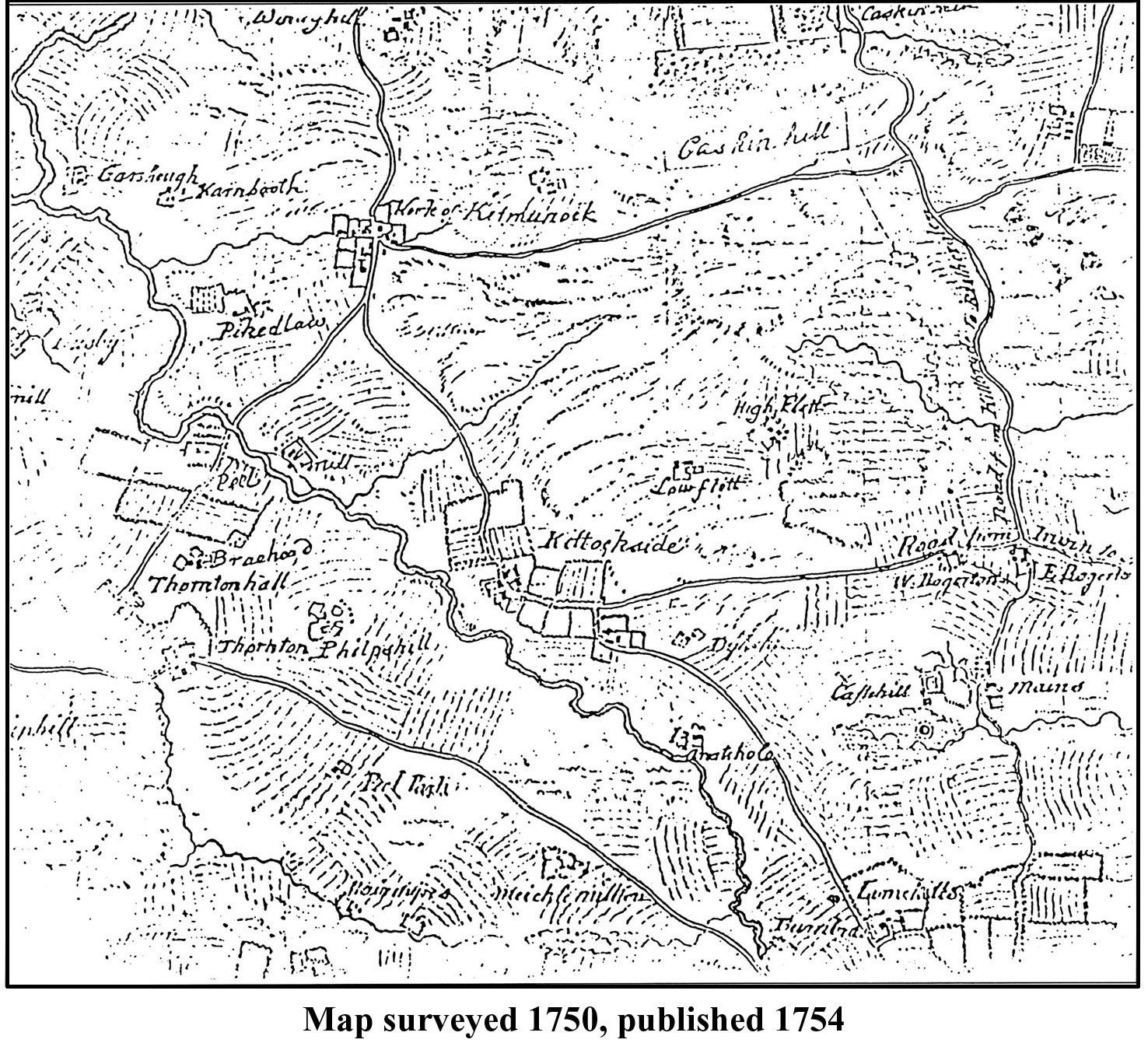
For centuries a path, including the existing cart-track from Pedmyre to Kittoch Mill (now severed by the by-pass road), must have led from Carmunnock’s crossroads down to the White Cart’s ancient mills at Busby, but no road is shown on 18th century maps and this is in contrast to those marked from all other directions. We could reasonably surmise that this cart-track to Busby started from the crossroads along the present Lane, passed the front of Bankhead Farmhouse, and high on the north bank of the Tammy Linn, it continued behind today’s bungalows at 30-40 Busby Road, to meet Pedmyre Lane as it passes the house on its way to the Mill.
None the less it is interesting that all round our district the cross-country routes used for centuries to reach mills, farms and villages, are still our much-used roads today, surfaced and maintained. The seven roads to Carmunnock still exist: Cathkin, the moors one (from the old Dam near Highflat Farm) and Kittochside Road come downhill into the village, and those from Waterside, Waterbank and the ones from Busby and Glasgow, including from Windlaw, come up to it - all converging at this long-established spot.
East of the church, in Manse Road - at one time known as School Loan - only nos. 13 and 15 remain from that time. Note the crow-stepping on no. 13’s and the recently placed stepped stones on the old schoolhouse’s gable at no. 11; note the mounting stone at the front of no. 15 and the corner-groove cut at the rear. West of nos. 15, 13 and 11 (the schoolhouse), was another cottage, all of them thatch roofed, a row as now; note the original stone dated 1736 (perhaps later than time of building) which has been placed on the rebuilt gable of no. 9.
Until some 45 years ago, there were another two 18th century houses at the foot of the Loan. Nowadays the west gable and fronts of these two, roughcast and whitened, serve as the garden wall of Kirkennan Cottage.
The 18th century Manse, before the 19th century one which was demolished in the late 1960s, stood with its stables and outbuildings on the same site, where Sycamore Way is now.
Going north along Kirk Road, across from the church is a house (now known as Kirkennan Cottage) of about 1780, handsomely fronted with squared sandstone sets neatly punched and dabbed with “levellers, risers and snecks” probably by an independent owner. It is thought that this cottage, which consisted of two small houses until the earlier part of the 20th century, was for a time the Laird’s property where members of his staff were accommodated.
On the north side of the Burn, early dwellings doubtlessly once existed along to the corner - where the Kirkgrove complex is now. At this point you had to cross the foot of a now non-existent little street known as Rowan Bank describing the one-time greenery there. It cut through to the Cathkin Way (now the top part of Busby Road). This little right-of-way was still in use up to the early 1970s when Bishops’ Cottage was converted; the small area for car parking outside the Cottage and Kirkgrove, and at the top end, the path leading to Rowanbank’s front door are all that is left of it.
Across the Kirk Road end of the little street till so recently a right-of-way, an attractive 17th or 18th century cottage facing west down Busby Road, stood out on the corner of the then footpathless and much narrower crossroads. This was the Craigenputtock Tearoom with an extension at the back in which a dovecote was built into the wall (all knocked down in the 1940s). Its back garden was on a triangle of ground between the little street just described and Cathkin Way, partly on our present-day footpath and the area of grass in front of Bishops’ Cottage.
Turning northeast up this little street to the top part of Busby Road or Cathkin Way, Bishops’ Cottage at 7 Busby Road formerly the Weaver’s Cottage, is so-named because the surname of the people who lived in it in the 1920s was Bishop and it is from then that the house’s name changed. Until 1970 its doorway was central in traditional cottage style and on its lintel stone was the date 1698.
Next to it there may once have been a row of cottages where the 19th century rubblestone building with its squared facings has taken the location’s name Rowanbank. Further along, in line with these (where Waterside Court is now) was a very old one known early in the 20th century as Coulters’ Cottage and then as Torrance’s - the last thatched house in Carmunnock. This 17th century cottage stood on the far corner at the bend of the road, a quaint and rather sad old sight until 1948.
The cottage opposite this, at 2 Busby Road, probably 18th century, may long ago have had a neighbouring one which in the 19th century was reconstructed into what is now the newsagents’ shop at 4 Busby Road with a house above it. Built of rubblestone, its windows handsomely framed with squared sandstone, no. 4 is similar in style to Rowanbank - both buildings perhaps replacing 18th century cottages.
At the village’s crossroads, two pretty 17th century cottages taking the name of tall trees to the back and west of them, The Beeches, stood where the sitting area, tearoom and Post Office on Busby Road are now. (The cottages and the trees were removed in the 1930s). The gable-end of the eastmost of these, was as far up as the kerb-edge of our present-day footpath on Kirk Road, and their long narrow garden full of fruit and flowers, ran past the Holy or Hallow Well down Busby Road, as far as the foot of Trestermyre’s ground.
Across from The Beeches, on the north side of Carmunnock Burn which flowed freely down the mill road (Busby Road) in those early days, three 17th century cottages now stood on the site of the early dwellings that were the Monkeries or the Monastery. While the cottage at the west end no longer exists - note the grass-covered foundations, the faint outline of its gable on the neighbouring wall and the broken gate and steps that led up to it - the 19th century reconstruction and development of the other two are now 8 and 10 Busby Road.
On Linnbrae’s 18th century 6 acres of land further down the old mill road, a house was built between 1830-60, part of it reconstructed late in the century into the fine square villa Linnbrae behind its high garden wall. Although of the later century, note while on this chapter’s subject of stone that Linnbrae’s windows and doors are framed with fine squared sandstone, but the rear wall of the house is of rubble-stone, no doubt taken from the original building whose remaining wall now forms the entrance from the Lane.
Next to it is Bankhead Farm of the 1760s where the bee boles belonged, its steadings attached on the west and a cottage behind them; this latter was demolished about 1963 and in 1983 a modern bungalow went up in its place - 20A Busby Road. Two old cottar houses east of the farmhouse, improved early in the century into holiday houses, were later used as hay barns before they were knocked down in the 1950s and replaced about 1972 in the Lane by 18A and 18B Busby Road. The farmhouse became a private residence in 1976, 20 Busby Road. Note its nice old window frames.
Some distance down Pedmyre Lane, off Busby Road, is Pedmyre House dating from about 1660. Owned till recently by Mr. and Mrs James Rait and today by the Goodmans, the house further developed in the 18th and 19th centuries nowadays incorporates part of its one-time farm buildings. Milnflat (76 Busby Road) found on a 1795 map has its two corbie-stepped roadside cottages beside it and, facing east, its dairy with little houses upstairs (this building now converted into one residence). Further west, the farm that was Carnbooth off one side of Busby Road and Picketlaw Farm off the other both appear on a 1754 map. Down towards the Kittoch Water, Kittoch Mill established in the 16th century sits at the bottom of its lane. And on Waterside Road, Waterside House, on the banks of the Kittoch, was the farmhouse said to have been built by the Laird of Castlemilk for his two spinster sisters in 1792, with the farm cottage and steadings next to it.
On the northwest corner of the village crossroads, dwellings with foundations said to be from the 14th century, stood on Main Street (nowadays Kirk Road). But it was in the 18th century that these buildings became a classic in architectural design when, with their old roofs away, two more storeys were built above the ground floor on its ancient base. With one door entering from the street and the other from the close to the downstairs houses, the spiral stone staircase starting with its base several feet out from the house’s rear wall, led up to the ones above, and there was also an inside stair.
Besides distinctive heavy rolled skew-putts, the most interesting feature is the Nepus gable on the front of this building in which a window at the side of the chimney, as well as two tiny dormer windows built out on the roof (probably at a later date) help to light the rooms at the very top. For a quiet country village, these lands, a tenement of domestic houses that was bigger and higher than any other (except perhaps the Manse) must have been regarded as one of the most outstanding in Carmunnock. There is a story that at the time of its transformation, a stone with the date 13— was found, the last two figures not clear.
In its back garden, a very deep Well with walls of a specially smooth-surfaced brick, was in use until about 80 years ago. Besides the several houses that the tenement contained, the building included a general grocer’s shop which, in new ownership from 1940, became a greengrocers for some years. Gradually, as tenants moved out, these new owners took over most of the building as their family home. Restored and replanned in 1983-4 into two private houses - happily retaining the attractive spiral stone stair at the back of the building - they are now 8 and 8A Kirk Road.
More 18th century houses in a 2-storey block were in line beyond along Main Street until the 1930s and the space where they used to be was in-filled in 1982 by 6A and 6B Kirk Road.
Then there was - and is - the 2-storey cottage-tenement built in 1798, a street door and one in the close to the lower houses and an inside stair leading to the ones above. Until 1961 there was a confectionery shop in the north half of the building. Reroofed, restored and replanned in 1974 into two private houses now known as 2 and 4 Kirk Road, the sculptured stone plaques on the front and rear walls replace little windows; and the skew-putts and distinctive shape and character of the building still clearly indicate its late 18th century origin. In European Architectural Heritage Year 1975, this restoration and replanning earned the Civic Trust’s Award for the architect David Miller.
Next to it - or, at a later date, between the little tenement and the 19th century house Ashtree - was an open area through which it is said Boghead Farm’s cows, crossing Main Street from the byre, passed on their way to graze in a field behind.
And further along the road beyond a marshy gap, in the direction of the hill down towards Glasgow, an early cottage on Stewarts’ (Stuarts’) land consisting of two or three tiny houses was in front of the present-day Jet Garage’s forecourt. This part of the road leading down the hill towards Glasgow was known as Netherton Road.
Opposite this an 18th century cottage toll-house stood until about 1920 where the War Memorial is now. Behind it, across a field, Gallowhill Farmhouse with its back to the village and its byre and steadings were some distance away among tall sycamore and chestnut trees. Now the three cul-de-sacs of Gallowhill Road’s houses occupy the site.
Boghead Farm on Main Street, thought to date from 1755 became the Boghead Inn in the late 19th or early 20th century, until it closed in 1974. Since then the building has been a restaurant. Note the wall-corner groove nowadays only faintly discernible at the bend of Waterside Road.
Across this bend on Waterside Road where this part was long ago known as the Fields Road, was an 18th century cottage facing north, its gable on Main Street. This was a grocer’s and hardware store until the 1930s, standing right out on the corner of the then much narrower and footpathless road, several feet beyond the present-day paved area in front of the Clason Hall. Tacked on at the back at that early time were another two little dwellings, and behind a high hedge a garden stretched as far as the crossroads. Next in line east of the old cottage on the Fields Road was the village blacksmith’s - the store, houses and 17th century Smiddy all demolished c. 1938.
On the Low Green, facing south towards the Well and the two crosses (all now long disappeared), the row of 18th century cottar houses at Sunnybank - nowadays restored and modernised into three private houses - probably belonged to Boghead farm on the site behind them.
At the top of the Green further up the Burn, the late 19th century cottage where Mrs Jean Crawford lived, was two houses at first, reconstructed from 18th century walls and foundations. And to the south where Cameron Crescent is now, were the High Green and Carmunnock’s main Whinstone Quarry which closed in the 1930s.
Within its few acres, 18th century Carmunnock was just beginning to establish itself as the village we know today. Only the wealthy could afford to build houses of two or more storeys at that early time, and only in the towns and cities was there the labour or the need to build high, thus conserving space. In an unimportant country village like Carmunnock at the back of the hill, with the church its only prestige building, most of the cottages belonging to the Lairds of Castlemilk and to a few other landowners of that time, were little and low with only a few small windows.
The cottage-tenements with upstairs houses (where 2, 4, 6A and 6B Kirk Road are now) built by Laird Stuart of Castlemilk for mill workers, were the exception. Interestingly, the 2-storey lands south of the church (32 and 34 Kirk Road) are thought to have been built by the previous Laird, Lord Hamilton for former Estate servants. More of these former Estate servants may even have been housed in the 3-storey tenement (8 and 8A Kirk Road), although this high structure is thought to have been developed by an independent speculating builder.
While some old-established houses in Carmunnock had a Well in their garden, other inhabitants drew water from the public Wells in the village or from the many springs. By the late years of the 18th century, cottagers cultivating their gardens began to grow fruit bushes and even some vegetables. Beyond the Kirkton cottages, the ones on the Green and on both sides of the Burn, were areas far greater than now of bleak, treeless country, common grazing ground, here and there a field sown with corn, kale or grazing grass, rough stony moorland and the Cathkin Braes. It would be a landscape almost unrecognisable in comparison to the tree-softened, mellower one of today.
If people had to move about the district, their route would be across moors or along rough paths and rutted muddy roads. Compared to the progress taking place in some parts of Scotland, this rural little area was backward and forgotten. Only about the middle of the 18th century for instance, did wheelmaking for farm and load-carrying work begin to develop beyond simple wooden discs. But by the end of the century, tools and implements were becoming more efficient for new skills. Development of the land had started - draining it, protecting it from harsher weather and enriching the soil.
And it is here that we reach the time in the 1790s of which the Rev Adam Forman and David Ure wrote. (See the Visitors’ Centre at Torrance Castle, Calderglen Park, East Kilbride).